Gisborne (March 27-31)
During the five days we were in Gisborne we had ~three days of nice weather and
we were able to do most of what we wanted to.
We ended up staying at Rayvon’s for the whole time instead of moving to
stay in town. We had the beach nice and
close to tan and relax and go for walks/runs along in the late afternoon.
Unfortunately there weren’t any good swells during the time we were here so the
planned surfing didn’t end up happening.
After the group we were traveling with left, the place only had about
five other people, two being the owners and three being wwoofers working for
accommodation so it was pretty quiet; a nice change from the busy and noisy
hostels. The last two days were
rain-filled so we spent that getting caught up on e-mails, the blog, etc.
The last morning we were there we decided to wake up in time
to see the “first sunrise in the world”. Pretty cool to take it all in at the
beach but it was a disappointing view with so much cloud cover. Definitely
should have done it the first morning as we heard it was perfectly clear. Oh
well, live and learn. And there would be many more to see, just not at the “first
place in the world to see [it]”. Later in the morning we were driven into town
and had a few hours to explore Gizzy before we started our trip back to Rotorua.
We ended up running more errands than spending time looking around but it was
needed. Just before we started the “Go East” part of our trip my second pair of
jandals (what the Kiwis call flip-flops; Japanese sandals) broke so I was in
search for a new pair. We also had a few things we needed to send out. During
that time though we got a decent sense of the city. Gizzy is another surf town
but is much bigger than Raglan ( ~33,000 compared to ~2,700) with a significant
percentage of the population being Maori.
There is a fun relaxed vibe to the town and it is covered with interesting
artwork.
 |
| Lounging in the back with Rayvon's pet dog, Georgie (don't let Scarlet see this!) |
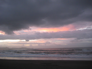 |
| About as good as the sunrise got (April 31, 2012) |
 |
| Some funky bus stop artwork |
 |
| The big clock tower on Gladstone Road |
After our few hours
were up we started our trip back via the Waioeka Gorge. This had been closed
for the past week or so due to a slide but had thankfully opened up the day
before. Although there was still a lot of clean-up from what we saw, it seemed
safe enough to travel through and still had beautiful views. We were able to
enjoy these views a bit more by going for a couple short walks. Thankfully too
because driving through the Gorge was just as windy and sickening as the East
Coast.
 |
| Clean-up of the slide from the vehicle |
 |
| A view of the Waioeka Gorge |
We arrived in Rotorua early evening and just took it easy as
the next morning we were heading back to Taupo and continuing our travels
further down throughout the North Island.
 |
| Thanks for a fun trip along the East Coast, Jason! |
 |
| Stayed at the Funky Green Voyageur that night |
Rotorua to Taupo (April 1)
It was the second time traveling from Rotorua to Taupo with Stray but it
felt like a completely different trip with a new driver; and completely
different in a good way. Unlike last
time, we were provided with a lot of interesting information and history during
our drive and were well-informed of all the activities we could participate in
while in Taupo. We also stopped at a look-out point for a good overall view of
Lake Taupo (the same size as Singapore!) and the town and enjoyed a short stop
to check out Huka Falls (the power and amount of water from these falls can
fill an Olympic-sized swimming pool in three secs or three pools in five
secs!). This driver, “Trouble”, turned out to be our favourite driver and we
stayed with him until Queenstown.
 |
| A view of the town and lake |
 |
| Part of Huka Falls |
 |
| Difficult to capture the power of the Falls |
The weather was quite poor again in Taupo but we took it in
a bit more this time by going for a run around a bit of the lake. We also stopped at this one section called
“The Great Lake Hole in One Challenge”. The hole is on a dock out on the lake
and from the walkway outlining the lake you can try and hit your ball for a
hole in one and win $10,000. We didn’t witness anyone who made it.
 |
| A closer view of the lake |
 |
| "The Great Lake Hole in One Challenge" |
We just spent the afternoon and evening here then we were off
to remote Whakahoro the next morning.
Whakahoro (April 2-3)
It was a relatively short drive from Taupo to Whakahoro but wow, what a
ride! Once again, there were a lot of twists and turns along the way but some
major bumps to add to the “adventure”. It didn’t help that we were in the back
of the bus where you feel the bumps the most! The beauty of the area was able
to distract us a bit from the roughness.
 |
| A view of the landscape in between bumps and twists |
Our accommodation for the night was at Blue Duck Lodge which
is an eco-lodge and conservation area. Along with our typical orientation of a
new place we learned a bit about the area and the endangered Blue Duck. We also
learned about the possum and that it is one of the major pests in New Zealand
and that wild boars are one of the main reasons that the Blue Duck is
endangered.
 |
| The main house |
 |
| Adrian with a wild boar statue made out of wood |
 |
| Where we stayed the night |
 |
| Free axe throwing! |
We only had an afternoon and evening at Blue Duck Lodge so
we attempted to make the most of it by going for a longer walk to a waterfall.
It was gorgeous weather which was great because the walk took about two hours,
there and back. We made it back just as the sun was going down. After supper we
all gathered around the fire pit and got to know everyone a bit better. (This
new group we met up in Rotorua after the East Coast trip)
 |
| Landscape for our walk |
 |
| Some box beehives along the way |
 |
| At the waterfall |
Tongariro National
Park (April 3-4)
Tongariro National Park was our next stop and is home to one of the best day
hikes in the world- the Tongariro Alpine Crossing. Unfortunately, very
unfortunately, we found out the night before that we wouldn’t be able to do it
because the weather was so poor. Gale winds of over 100kmp and rain. We were
really looking forward to it, thought it would be a good challenge as it takes
at 6-8 hours to complete and the elevation makes for unpredictable weather.
When we arrived in the Park, our driver took us to do a much
shorter alternate walk to see Taranaki Falls. It was a loop trail that took about
an hour but the winds slowed us down a bit. It was warm and sunny but the winds
were pretty brutal without the protection of the trees every once in a while.
Along the way, we took glances of the Crossing and we were glad they canceled
the hike; it looked pretty rough up there.
 |
| Edge of the lava flow |
 |
| Taranaki Falls, ~20m |
Once you enter the National Park, you get views of Mount
Ngauruhoe (aka Mount Doom from Lord of the Rings) and Mount Taranaki (featured
in The Last Samurai with Tom Cruise). On the way back to our accommodation for
the evening, our driver also took us to what is known as “Gollum’s Pool”, the
area where the scene of Gollum hitting a fish over the head on a rock was
filmed. I felt like such a nerd excited to see all this but at the same time
it’s pretty cool to say you’ve seen it or been there.
 |
| "Mount Doom" |
 |
| Tongariro Alpine Crossing |
 |
| Gollum's Pool |
Our accommodation for the night was a nice change from the
hostels. It was more of lodge with a café, restaurant and bar in it but there
was still a communal kitchen and common room like we’re used to. The rooms were
a neat set up- four beds in total but two were upstairs and two downstairs so
you had a bit of privacy without paying for a double or twin room.
We considered sticking around a couple more days to try and
do the Crossing but the forecast called for more strong winds and rain. We
could have done alternate walks but not having a vehicle limited us quite a
bit. So in the end we decided to move on to the next place with the bus.
Wellington (April 4-5)
The next place on the itinerary was Wellington, New Zealand’s capital. On
the way there we passed Ohakune and stopped for a fuel-up in Bulls. Ohakune is
traditionally the “carrot capital” of New Zealand and to really embrace this,
the town has erected a giant carrot in the centre (a common thing for towns to
do- have statues of fruit, vegetables or animals the town is known for) and has
an annual carrot festival. More recently they have come to be known as the ski
capital of the North with skiing/snowboarding at Mount Ruapehu close by. Bulls is
a fun town where everything is “bulls-based”. For example, the police station
is called “Const-a-bulls” with a mural nearby with bulls dressed up in cop
uniforms.
 |
| Signpost in Bulls |
 |
| With the "Const-a-bulls" |
We arrived in Wellington late afternoon and unfortunately
came into some poor weather. But considering we were only going to spend this
one afternoon here, we made the most of it. After checking into the hostel (which
was once known as the Historic Hotel Waterloo hosting the Queen’s entourage on
her 1953 Coronation Tour of New Zealand), we started on our walk. Thanks to the
Lonely Planet guide, we followed the walking route they have mapped out and
checked out the Beehive (in some people’s opinions, one of the ugliest pieces
of architecture in the world) along with other parliament buildings, the
popular roads of Lambton Quay and Cuba Street, and ended up at the national
museum, Te Papa. We’ve heard it takes approximately two full days to see and
read everything in the museum so with only an hour and a half we were pushing
it. It was a pretty impressive museum. We learned about the history of the
nation, the Treaty of Waitangi and the controversy with it, the history of the
land and how it has developed into what it is and provides now, and a lot about
the Maori lifestyle and culture.
 |
| The Beehive |
 |
| Lambton Quay |
 |
| Cuba Street |
 |
| Te Papa |
The setting of the city is really nice with the harbour on
one side and the rest of the city surrounded by bushy hillside. The arts scene
is great here with galleries, museums and such. And the number of cafes is
insane. It reminded me quite a bit of San Francisco but nowhere near as
overwhelming even considering it was one of the largest cities/towns we had
been to in a while (pop. ~165,000). One of the downfalls of the city is that it
sits on a major fault line and many people expected it would be hit by a devastating
earthquake at some point instead of Christchurch. Also, because it lies at the
bottom on the North Island with the Cook Strait at its doorstep, very strong
winds come through on a regular basis. So strong, buildings have ropes attached
to them for people to hold onto during their walking commute. Thankfully we
didn’t experience those kinds of winds!
 |
| Surrounded by bush |
The next morning was an early start with having to be at the
ferry terminal for 7:15am. Conveniently though, our hostel was directly across
the street from it!
Having made the ferry trip before to work in Blenheim, there
wasn’t too much to get excited about. True, the weather was better than last
time so we took some more pictures. And this time we had more people to share
the trip with, sticking with the group we met in Rotorua. I think this is
probably where we all started getting to know each other a bit better actually.
There was:
·
Holly – an English girl who had been working in
Thailand the past little while as a scuba diver
·
Stacey – also from England and had recently
traveled through Africa and Australia
·
Kyla – another Canadian living and working near
Camrose, originally from Ontario
·
Jochen – a German dairy farmer traveling New
Zealand for four months before he returned back to work
·
Glyn & Sam – an English couple traveling New
Zealand and Australia for 3 months
The three hours actually passed quite quickly and before we
knew it we had arrived in Picton. There we picked up some more people and
almost doubled the number of people on our bus! Next stop, Marahau, on the
outskirts of Abel Tasman National Park!